Cho Lab Showcases Research at AGU 2025
Date: 12/20/2025
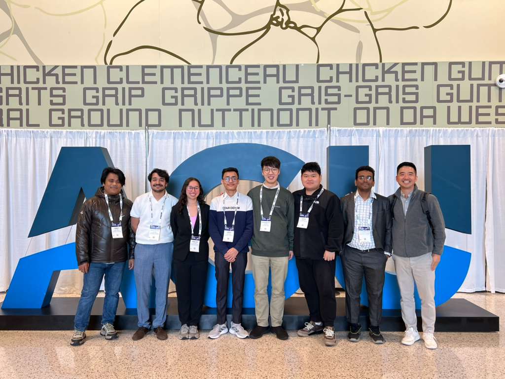
Last week at AGU 2025- the largest conference on Earth and Space Science, was an especially meaningful and proud moment for ChoLab and our members, where we presented our research, exchanged ideas, and engaged with a diverse community of scientists working across hydrology, climate, agriculture, and environmental systems.. All of this was made possible by the incredible students and postdoc who the Cholab is proud to be working with.
Research Presentations & Abstracts:
Dr. Eunsang Cho
Research Focus: Quantifying Snow Sublimation Patterns over the Continental U.S.
Abstract: Snow sublimation - the direct transition of snow to water vapor - represents a critical loss term in seasonal snowpack mass balance, especially in cold and semi-arid regions. However, its spatiotemporal variability and long-term contribution to the water cycle across the United States remain poorly quantified due to limited observational data and modeling uncertainty. To address this gap, this study utilizes operational high-resolution outputs from the Snow Data Assimilation System (SNODAS) to analyze snow sublimation trends across the Continental United States from 2004 to 2024. SNODAS provides daily 1-km estimates of two sublimation components: canopy sublimation from intercepted snow and ground snowpack sublimation. We aggregated these outputs to monthly and annual scales and analyzed spatial variability across major hydrologic units, as well as interannual trends and anomalies. By quantifying both components of sublimation using consistent SNODAS-derived estimates over two decades, this study provides broad insights into overlooked snowpack losses within hydrological cycle across diverse U.S. climates. These results support improved snow modeling, enhanced hydrologic forecasting, and a more complete understanding of snowpack changes under a warming climate.
Dr. Eunsaem Cho
Research Focus: Improved Snowmelt Flood Simulation through GRACE/GRACE-FO Data Assimilation in Noah-MP
Abstract: Groundwater dynamics have significant potential for advancing large-scale snowmelt flood predictions due to their long-term memory of past meteorological conditions and interactions with near surface processes such as soil moisture. The objective of this study is to evaluate how improved groundwater representation through Gravity Recovery and Climate Experiment (GRACE) and GRACE Flow-On (GRACE-FO) data assimilation can improve snowmelt flood simulation, with a focus on historical extreme flood events. GRACE data assimilation experiment is carried out using the Noah Land Surface Model with Multi-Parameterization options (Noah-MP) and the NASA Land Information System (LIS). Streamflow simulations are generated through the Hydrological Modeling and Analysis Platform (HyMAP). This study assesses the effectiveness of GRACE data assimilation in improving groundwater representation and subsequent streamflow predictions in north-central U.S. basins from 2005 to 2024, with particular emphasis on major snowmelt flood years including 2006, 2011, and 2019. Following the implementation of GRACE data assimilation for enhanced groundwater storage estimation, we evaluate model performance improvements by comparing GRACE-enhanced and open loop Noah-MP simulations along with USGS groundwater well and streamflow gauge observations. We expect that GRACE data assimilation will improve the representation of groundwater variations, resulting in more accurate snowmelt flood simulations with better reproduction of peak flow magnitudes and their temporal dynamics.
Email: eunsaem.cho@nasa.gov
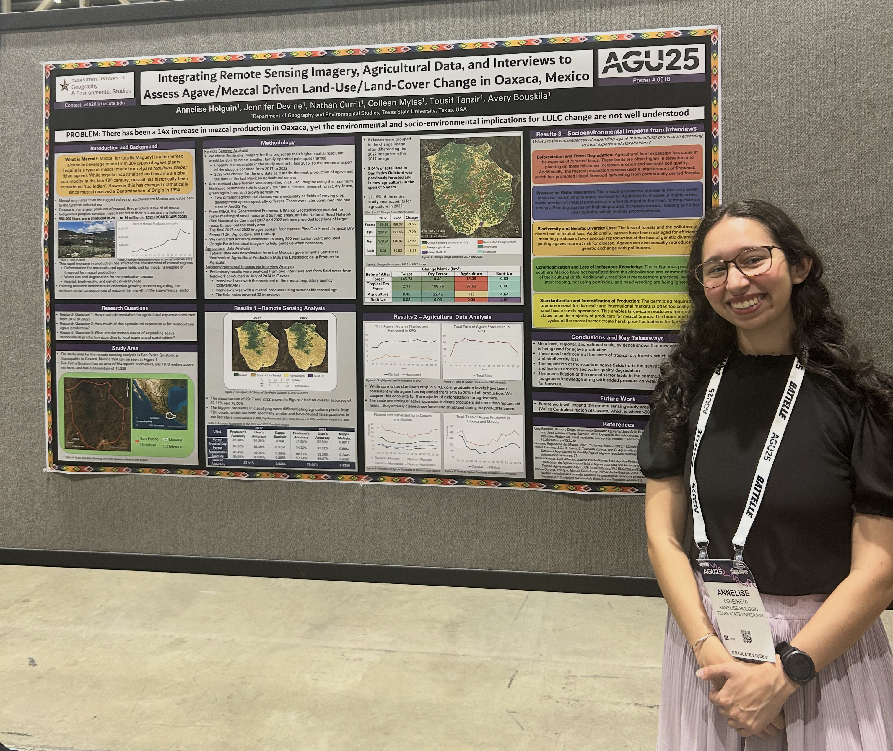
Annelise Holguin
Research Focus: Sub-Field Crop Yield Prediction Using Satellite-Based Machine Learning: A Multi-Year Analysis with USDA-ARS Ground-Truth Data
Abstract: Accurate crop yield prediction is essential for ensuring food security, optimizing agricultural management, and supporting economic planning. Machine learning (ML) techniques using satellite remote sensing data can be a valuable tool for estimating crop yield, particularly in regions where ground-truth data is limited or unavailable. However, a major challenge remains the lack of high-quality ground-truth data for calibrating and validating remote sensing-based yield estimates. To address this gap, the USDA Agricultural Research Service (ARS) Hydrology and Remote Sensing Lab has published a multi-year, sub-field crop yield raster layer for 2014 to 2024 at the Beltsville Agricultural Research Center (BARC) in Beltsville, Maryland. The dataset includes yield measurements for approximately 20 fields per year at a 5-meter grid scale. This research leverages the BARC dataset and employs a MLs techniques to develop and validate sub-field yield predictions for corn (Zea mays L.), soybeans (Glycine max (L.) Merr.), and winter wheat (Triticum aestivum L.). Specifically, a Random Forest Machine Learning (RFML) regression model, utilizing satellite-based datasets (Harmonized Sentinel-2 and Landsat 8 data) implemented on Google Earth Engine’s cloud computing platform, is used to accurately predict crop yield at the sub-field scale. The model's performance is evaluated against ground-truth data, achieving average R2 values of 0.82, 0.90, and 0.86 respectively for corn, soybean, and winter wheat. Other tests are run to evaluate on unknown fields and unknown years, to see if the model can work with reduced inputs and reduced time, to train the model on multiple years of historical yield data, and to detail variable importance for each crop. These tests yield similar results to the initial model results, and land surface temperature and VIs are found to be the most influential on yield prediction, with variability across crops. The findings of this study contribute to advancing precision agriculture by enhancing the predictive modeling of crop yield at fine spatial resolutions. The developed ML model offers data-driven insights that can assist farm managers and policymakers in optimizing decision-making, ultimately improving yield forecasting and resource allocation in agriculture systems.
It was excellent to meet scientists from around the world and around the scientific disciplines. I learned a lot and it was exciting to see the research projects of so many contemporaries.
Email: annelise.holguin@txstate.edu
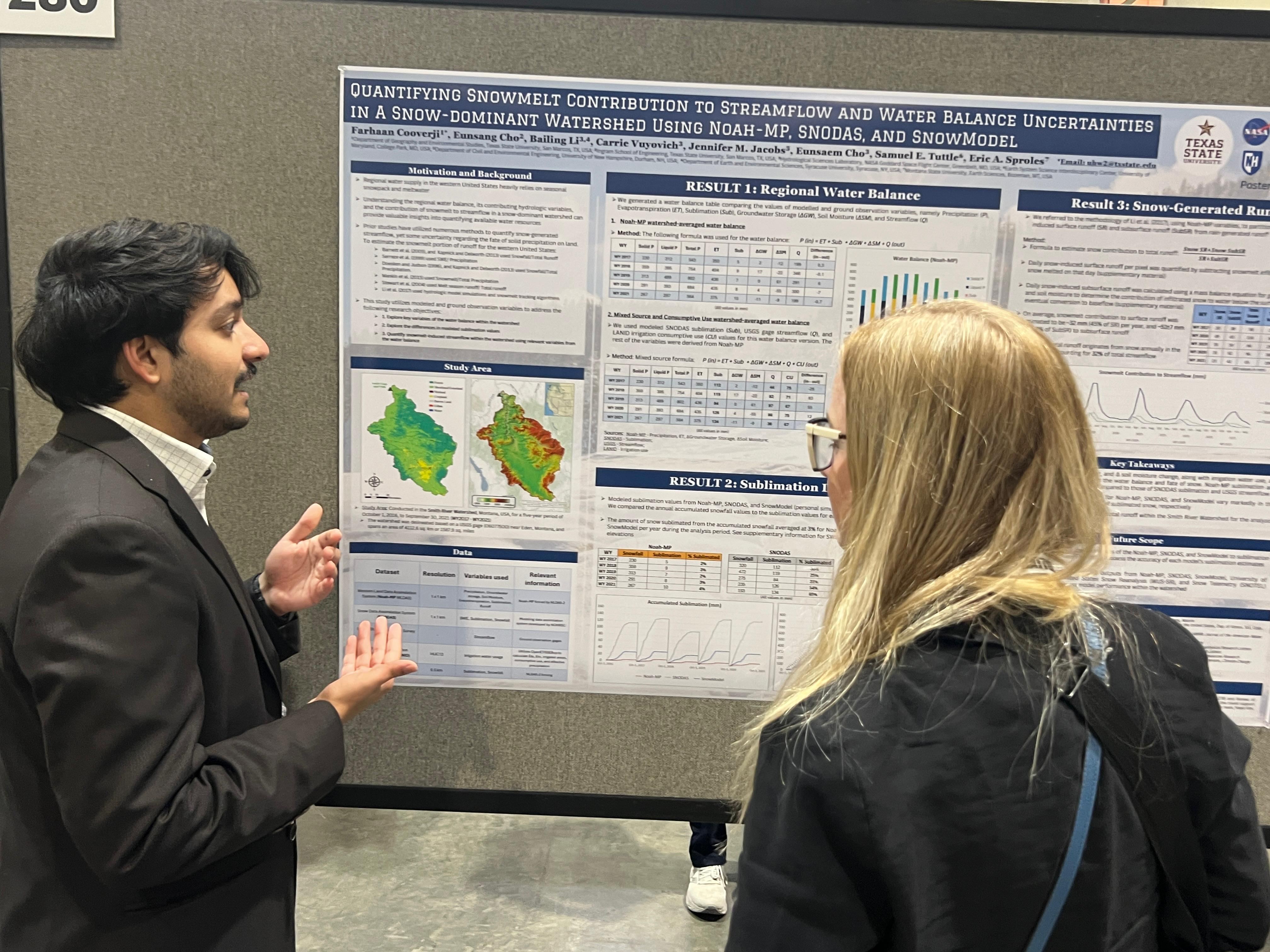
Farhaan Cooverji
Research Focus: Quantifying Snowmelt Contribution to Streamflow and Water Balance Uncertainties in a Snow-Dominated Watershed Using WLDAS and Multi-Source Datasets
Abstract: Regional water supply in the western United States heavily relies on seasonal snowpack and its subsequent meltwater. In snow-dominated watersheds, accurate quantification of the snowmelt contribution to streamflow is critical for quantifying water availability and understanding the interannual variability of water resources. However, uncertainties in estimating meltwater from snowpack hinder accurate quantification. Process-based modelling approaches are commonly employed to generate spatially distributed hydrologic estimates and compute the watershed-scale water balance evolution. Our research estimates the amount of snowmelt contributing to streamflow in the Smith River Watershed, Montana, using spatially distributed hydrological variable outputs from the 1-km gridded Western Land Data Assimilation System (WLDAS), which employs the Noah-MP land surface model and is forced by downscaled NLDAS-2 meteorological data in the NASA Land Information System (LIS). We also incorporate independent and reliable snow-relevant products from the Snow Data Assimilation System (SNODAS) and streamflow data from the United States Geological Survey (USGS). Results reveal that WLDAS sublimation and total runoff differ significantly from SNODAS sublimation and USGS streamflow, noticeably impacting the water and energy balance components within the watershed. WLDAS also underestimates evapotranspiration (ET), likely due to the omission of irrigation water use. Therefore, we incorporated crop and irrigation water usage data from the LANDSAT-based Irrigation Reanalysis Dataset (LANID) to improve the estimates of the water balance components. To further refine sublimation estimates and validate modelled snow variables (e.g., SWE and snowmelt), we compare SnowModel outputs with those from WLDAS and SNODAS. Lastly, we adapt the pixel-level runoff partitioning method to quantify the contribution of snowmelt to surface and subsurface runoff. This work provides an integrated framework for quantifying snowmelt contributions to streamflow and highlights uncertainties in current Noah-MP land surface model outputs.
Email: uhw2@txstate.edu
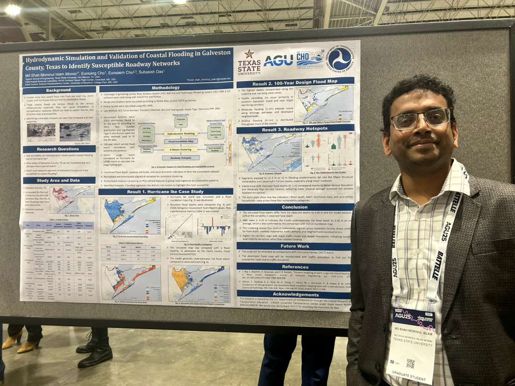
Md Shah Mominul Islam Momin
Research Focus: Hydrodynamic Simulation and Validation of Coastal Flooding in Galveston County, Texas: 2008 Hurricane Ike Case Study and 100-Year Flood Map Development
Abstract: Compound flooding—driven by the combined effects of storm surge, extreme precipitation, and sea level rise—poses growing risks to coastal communities. Understanding these complex flood dynamics through high-resolution simulations is essential for developing effective coastal flood mitigation strategies and enhancing community resilience. This study simulates and validates coastal flood inundation for Galveston County, Texas, using the HEC-RAS 6.6 hydrodynamic model, with Hurricane Ike (2008) as a reference event. A high-resolution hydrodynamic flood simulation was conducted using the U.S. Army Corps of Engineers' HEC-RAS 6.6 model to reconstruct the Hurricane Ike (2008) flood event. The model integrates a wide range of topographic, meteorological, and coastal datasets, including 3m-resolution DEM (USGS), NOAA sea water levels and storm surge data, and NLCD-based land characteristics. Simulated flood depths were validated using FEMA high water mark (HWM) observation data and the Harris County Flood Control District flood maps, showing R2=0.615 with observed inundation levels. Following validation, a 100-year return period coastal flood scenario was generated to represent future flood risks under extreme conditions. The resulting flood hazard maps reveal extensive low-lying areas at risk, highlighting the importance of high-resolution hydrodynamic modeling for informing infrastructure resilience and emergency preparedness. Future work will integrate these inundation maps with transportation and socio-economic data to identify roadway vulnerability hotspots and inform coastal adaptation planning.
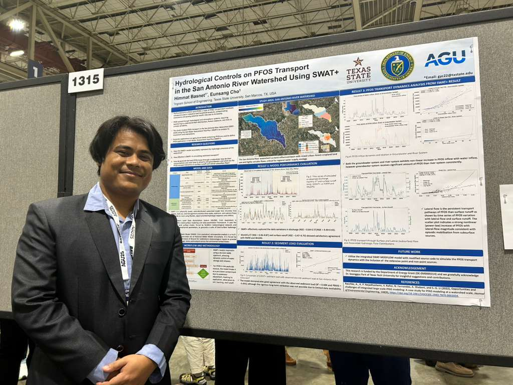
Himmat Basnet
Research Focus: Hydrological Controls on PFOS Transport in the San Antonio River Watershed Using SWAT+
Abstract: Per- and polyfluoroalkyl substances (PFAS), including perfluorooctanesulfonic acid (PFOS), are persistent contaminants that pose significant threats to regional hydrology and water resources. However, the role of specific hydrological pathways in controlling PFOS transport remains poorly understood in semi-arid environments, particularly those with complex interactions between the surface and groundwater. This study addresses this gap by simulating the fate and transport of PFOS in the San Antonio River Watershed, Texas (2005–2024), using the Soil and Water Assessment Tool Plus (SWAT+). Model calibration and validation are conducted using USGS streamflow data, NOAA’s National Water Model, and NASA’s Western Land Data Assimilation System, and confirm the SWAT+ model's capability to simulate key hydrological processes.
PFOS fate and transport were simulated using the pesticide module, with agricultural applications serving as the primary source. Results show that groundwater inflow is more consistently correlated with PFOS transport than runoff leading to the streams, indicating long-term subsurface accumulation. Surface runoff and lateral flow both act as major transport pathways, particularly during high-flow events. Power-law relationships captured a nonlinear scaling of PFOS with surface runoff, whereas lateral flow showed a more stable and immediate response to PFOS, suggesting tightly coupled subsurface dynamics.
These findings highlight the importance of representing both surface and subsurface hydrological processes in PFAS transfer modeling within semi-arid watersheds. A better understanding of flow-path-dependent contaminant dynamics with advanced simulations can support more effective PFAS mitigation strategies and inform regulatory decision-making.
Email: gyc22@txstate.edu
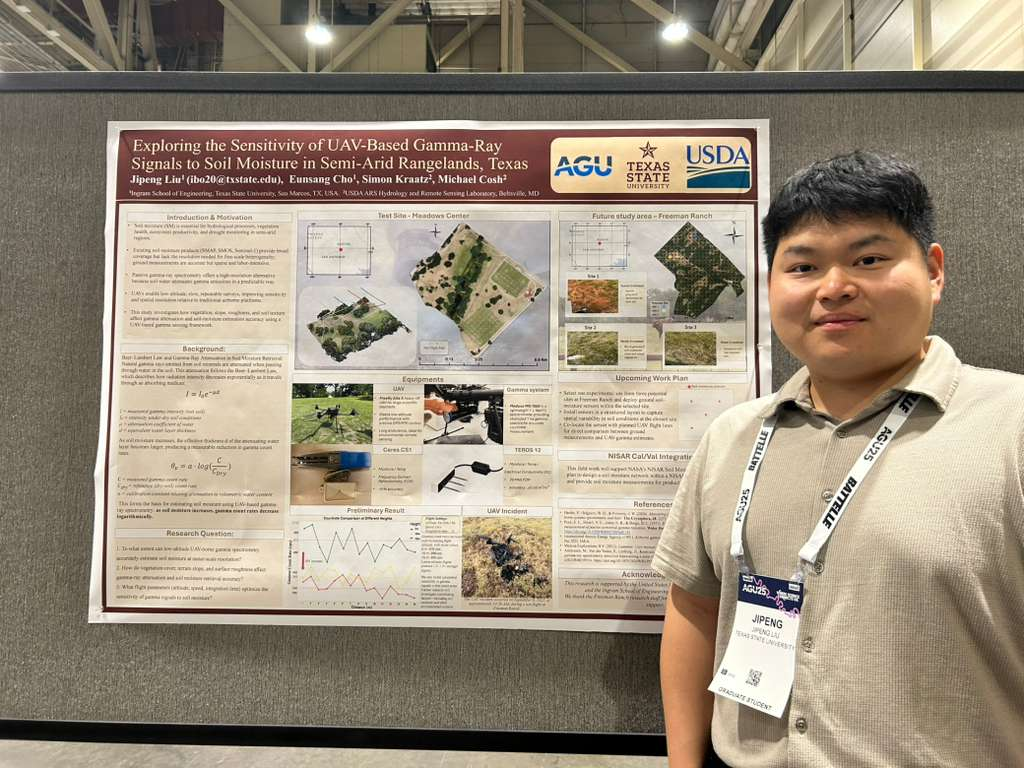
Jipeng Liu
Resaerch Focus: Exploring the Sensitivity of UAV-Based Gamma-Ray Signals to Soil Moisture in Semi-Arid Rangelands, Texas
Abstract: Accurate and high-resolution soil moisture monitoring is crucial for understanding hydrological processes, particularly in semi-arid environments where water availability and variability drive ecosystem processes, rangeland productivity, and drought resilience. Satellite remote sensing often lacks the spatial resolution or depth sensitivity required to capture fine-scale heterogeneity in soil moisture, while ground-based measurements are labor-intensive and spatially limited. Addressing this gap, our study explores the feasibility and sensitivity of using uncrewed aerial vehicle (UAV)-based gamma-ray spectrometry to estimate soil moisture at meter-scale resolution. We propose an integrated UAV remote sensing framework combining a low-altitude gamma-ray spectrometer (MEDUSA MS-1000) and a high-resolution LiDAR system (YellowScan) mounted on an Alta-X UAV platform. The study will be conducted at Freeman Ranch in central Texas, a semi-arid research site with complex terrain and mixed vegetation. Gamma-ray data will be collected at ~15 meters above ground to enhance signal strength for natural terrestrial isotopes (e.g., K-40), while LiDAR flights at ~100 meters will provide detailed surface structure and elevation data. With weekly flight missions, spatial ground-truth soil moisture data will be collected using portable probes to evaluate the sensitivity of gamma-ray measurements. This research will also aim to quantify how environmental factors, such as slope, canopy cover, and surface roughness, impact gamma-ray attenuation and signal interpretation. These interactions are often underexplored yet critical for advancing the accuracy of radiometric soil moisture estimation in heterogeneous landscapes. This presentation outlines the experimental design, sensor integration strategy, and anticipated data fusion workflow. By evaluating the environmental sensitivity of UAV-based gamma-ray signals and integrating structural insights from LiDAR, this research aims to inform future soil moisture mapping frameworks for applications in precision agriculture, rangeland management, and hydrological modeling.
Email: ibo20@txstate.edu
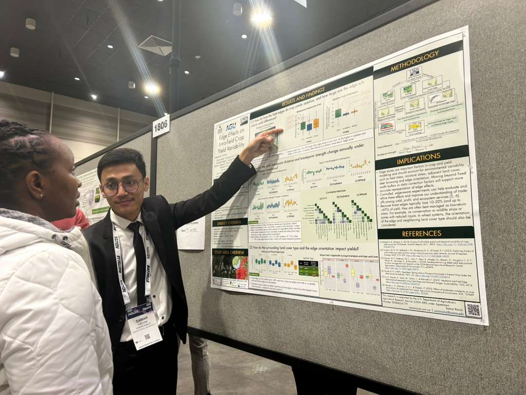
Samar Ranjit
Research Focus: Edge Effect on Intra-field Crop Yield Variability
Abstract: Understanding within-field yield variability is essential for effective agricultural management, enhancing crop productivity and sustainable food production. The edge effect created by field boundaries, shaped by adjacent land-cover types and environmental exposure, is a major contributor of within-field yield variation. However, the effective distance over which edge effects extend and their causes across different crop types remain poorly quantified. In this study, 5-m resolution gridded crop yield datasets, generated using kriging interpolation of yield monitor outputs, from 2014 to 2023 were used to analyze the spatial patterns of edge-related yield variation across 118 USDA agricultural fields in Beltsville, Maryland, focusing on soybeans, corn, and wheat. We also applied segmented regression models to assess how crop yield varies with distance from the field edge. Directional edge labeling and convex hull boundary reconstruction were used to calculate edge proximity and boundary type and structure. Our results indicate a consistent yield depression near field edges, especially those adjacent to forested land. Statistically significant breakpoints were observed in 66% of all field–crop combinations. Most of these occurred within the first 30 meters from the edge, beyond which yield stabilized, though the distance varied by crop type, with median values of 23m for soybeans, 29m for corn, and 26m for wheat. Interannual trends in breakpoints revealed that edge effects vary with growing season favorability as well as crop type. We also found that crop yields near the edges differ significantly depending on boundary types (e.g., forest vs. crop field). Field edges adjacent to forests exhibited more pronounced yield depression than next to other cropped fields, suggesting that wildlife activity and reduced fertilizer use may lower crop productivity near the forest. This study provides reproducible, spatially explicit methods and actionable insights for precision crop-management strategies and contributes to more efficient, resilient, and sustainable farming systems.
Email: samarranjit@txstate.edu
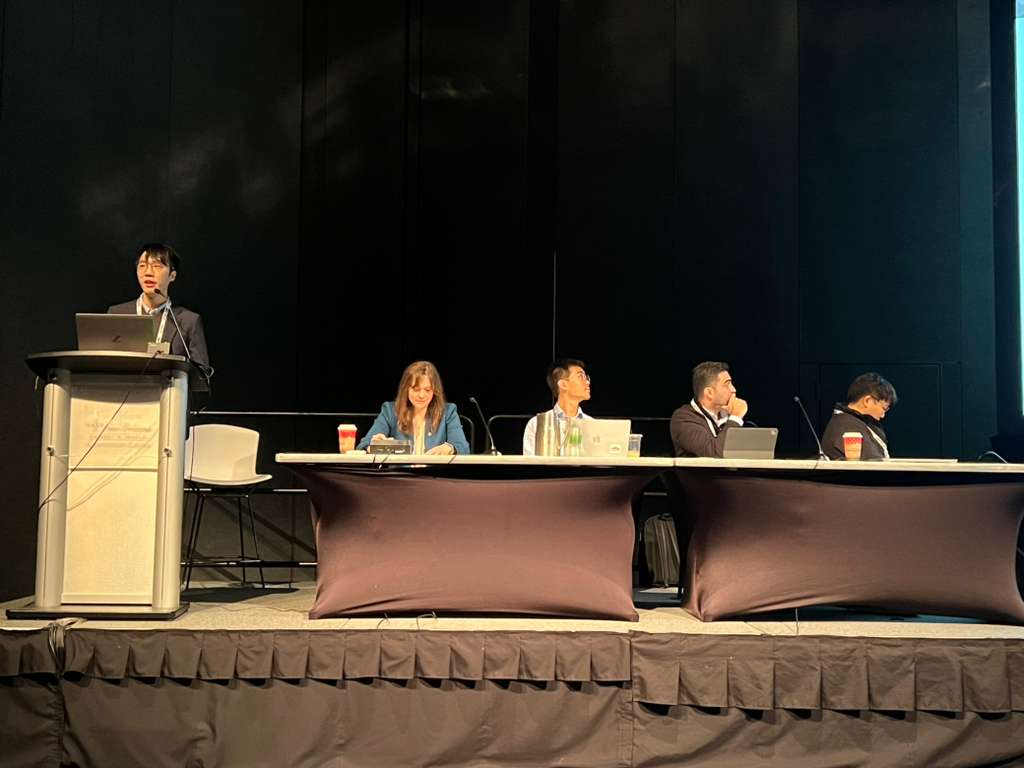
Beyond presenting their work, Cho Lab members spent significant time engaging with other research, attending sessions related to their fields, and building new professional connections with scientists and experts from across the world.
I’m so grateful to everyone our Cho Lab members had the opportunity to interact with! My students may reach out to you from time to time 😊
Other Images: